|
|
"The Portage" (Portage Hike and Bike Trail)
The main section of the asphalt-paved Portage Hike and Bike Trail is continuous between the Main Street bridge in downtown Kent and Peck Road on the east side of Ravenna. A bike-friendly staircase leads to Main St in Kent. Use Franklin Avenue to connect to the southern trail segment beginning at John Brown Tannery Park. Google incorrectly shows a bike trail from Main St along the riverside path behind the mills. This does not exist as a bike trail (stairs, roots, etc.). However, you can use the sidewalk on River St for a few hundred feet (it's one-way in the wrong direction) and then cut behind the old mill buildings along River St, rejoining the trail at Stow St.
The other spurs and segments are slated for future connections to this route. As of 2022, funding has been secured for completing the above-mentioned non-existant bike path between Main Street and Summit/Stow Street. West of downtown Kent, another segment stretches from John Brown Tannery Park to Middlebury Rd, near the end of the Freedom Trail. A switchback and bridge is planned to connect the two trails.
This trail system is jointly managed by Portage Park District, the City of Kent, the City of Ravenna and Kent State University. As of 2022-2023 there is significant heaving due to roots and seasonal changes on some of the sections between the downtown bike bridge near Fairchild Ave and Lake Rockwell Rd (City of Kent section). Some grinding has been done to reduce the hazard. As of early 2024, root/expanson heaves are showing up in other locations. The Portage Park District segments are slated for repair in April 2024.
Download a trail map and get more information at:
www.portagecounty-oh.gov/portage-county-park-district/parks-maps/pages/portage-hike-bike-trail
Connections:
- All safety issues related to road riding apply here. Wear bright colors, use flashing rear lights, and follow all traffic laws. Use at your own risk.
- Road connections from the Main Street Bridge Bike Stairs to either John Brown Tannery Park or Fred Fuller Park in Kent provide access to another segment that nearly aligns with Summit County's Freedom Trail at Middlebury Road. A spur off this segment also leads to Kent State University and the stadium parking lots.
- Road connections from either Fairchild Avenue or Riverbend Blvd (and from Riverbend through the Roosevelt HS and Stanton Middle School access road) lead to a trailhead at Hudson and Judson Roads. This trail segment is continuous with the main (northern) route of the Summit County Hike and Bike Trail. A future trail connection between the Hudson-Judson trailhead and the Towner's Woods Trailhead on the east side of Kent is on a wish list.
- A Road connection to the Headwaters Trail (HWT) just east of Mantua is possible using Peck Road. Technically, you are still on a (hiking) trail if you use this route, which is also part of the The Buckeye Trail.
- In late 2021 a short segment of trail was opened that connects the HWT to Mennonite Road at that trail's current western terminus. Wall St./Infirmary Rd. can be accessed from the Portage H&B Trail and will take you north to the Mennonite Rd. access point. HOWEVER, In my opinion, Peck Rd. is a safer cycling route.
The Headwaters Trail
This crushed limestone trail runs from Mennonite Road in Mantua to Route 82 in Garrettsville. Expansion to the west is coming soon and expansion to the east is planned. A short connector between the parking lot at the Garrettsville library and ball field parking area and route 82 was paved in 2021, and a ramp to Mennonite was opened in 2022. Note that apparent extentions west of Mennonite Rd and east of Rt 82, marked by Google as "Headwater Trail" (no "s" on "Headwater"), do NOT actually exist, at least as of 2024. Adding to the confusion, there are some driveways marked this way just north of the McDonalds on 44. Getting Google to remove such things is nearly impossible, as I've heard they want to mail confirmations to trail street addresses (which of course trails do not have). Makes you wonder how it was added in the first place. Using Google Maps with "Biking" mode turned on is a better option than just looking at labels on the default map view.
Download a Headwaters Trail map and get more information at:
www.portagecounty-oh.gov/portage-county-park-district/parks-maps/pages/headwaters-trail
Connections:
Turn by Turn Directions to the Western Reserve Greenway from Garrettsville (heading east):
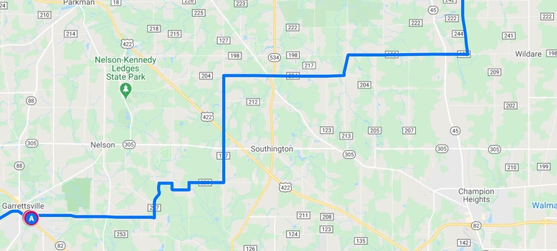
The Headwaters Trail appears to end at a parking lot for some ball fields. As you turn right towards the lot, you will note a short, narrow paved trail leading down to Route 82 on your left. Take this path (A). Cross 82 and turn right on the sidewalk. Immediately turn left into the supermarket parking lot and go behind the building and past the car wash. Turn left onto Liberty St. Turn right onto Silica St. This continues as Pierce Rd. When this road ends, turn left onto Newell Ledge Rd. At the end, turn right onto Knowlton Rd. At the tee, turn right to stay on Knowlton Rd. At another tee, turn left onto Shanks Downes Rd. Continue around a right bend where the road becomes Herner County Line Rd. Turn left onto Phalanx Mills Herner Rd. Turn right onto County Line Rd/County Line Turnpike Rd. Turn left onto Hoffman Norton Rd NW. Turn right onto G P Easterly Rd and continue onto Bristol Champion Townline Rd. Turn left onto the Western Reserve Greenway (heading north toward Ashtabula). Also see: Connecting to the Western Reserve Greenway and Cleveland Bypass for the Northern Tier Route
This crushed limestone trail runs from Mennonite Road in Mantua to Route 82 in Garrettsville. Expansion to the west is coming soon and expansion to the east is planned. A short connector between the parking lot at the Garrettsville library and ball field parking area and route 82 was paved in 2021, and a ramp to Mennonite was opened in 2022. Note that apparent extentions west of Mennonite Rd and east of Rt 82, marked by Google as "Headwater Trail" (no "s" on "Headwater"), do NOT actually exist, at least as of 2024. Adding to the confusion, there are some driveways marked this way just north of the McDonalds on 44. Getting Google to remove such things is nearly impossible, as I've heard they want to mail confirmations to trail street addresses (which of course trails do not have). Makes you wonder how it was added in the first place. Using Google Maps with "Biking" mode turned on is a better option than just looking at labels on the default map view.
Download a Headwaters Trail map and get more information at:
www.portagecounty-oh.gov/portage-county-park-district/parks-maps/pages/headwaters-trail
Connections:
- All safety issues related to road riding apply here. Wear bright colors, use flashing rear lights, and follow all traffic laws. Use at your own risk.
- As noted above, road connections to "The Portage" can be made via Infirmary or Peck Roads. In my opinion, Peck is a bit quieter and is also designated as part of the "Buckeye Trail." Shoulders are mostly narrow or non-existent.
- Quiet road connections to the Western Reserve Greenway are feasible (see static map and directions below and also see more information and an interactive map here: Connecting to the Western Reserve Greenway). This is a low-traffic option (I saw about 6 cars on a Sunday morning). It crosses a few busy roads.
Turn by Turn Directions to the Western Reserve Greenway from Garrettsville (heading east):
The Headwaters Trail appears to end at a parking lot for some ball fields. As you turn right towards the lot, you will note a short, narrow paved trail leading down to Route 82 on your left. Take this path (A). Cross 82 and turn right on the sidewalk. Immediately turn left into the supermarket parking lot and go behind the building and past the car wash. Turn left onto Liberty St. Turn right onto Silica St. This continues as Pierce Rd. When this road ends, turn left onto Newell Ledge Rd. At the end, turn right onto Knowlton Rd. At the tee, turn right to stay on Knowlton Rd. At another tee, turn left onto Shanks Downes Rd. Continue around a right bend where the road becomes Herner County Line Rd. Turn left onto Phalanx Mills Herner Rd. Turn right onto County Line Rd/County Line Turnpike Rd. Turn left onto Hoffman Norton Rd NW. Turn right onto G P Easterly Rd and continue onto Bristol Champion Townline Rd. Turn left onto the Western Reserve Greenway (heading north toward Ashtabula). Also see: Connecting to the Western Reserve Greenway and Cleveland Bypass for the Northern Tier Route